


Les Bouillas, les Brayes

Gegetop
User

Length
17.8 km

Max alt
1114 m

Uphill gradient
397 m
Km-Effort
23 km

Min alt
918 m

Downhill gradient
397 m
Boucle
Yes
Creation date :
2021-08-23 10:00:47.996
Updated on :
2021-08-23 14:48:01.185
4h30
Difficulty : Medium
4h06
Difficulty : Medium

FREE GPS app for hiking
 SityTrail
IGN / Geographical institutes
SityTrail Plus
The world is yours!
About
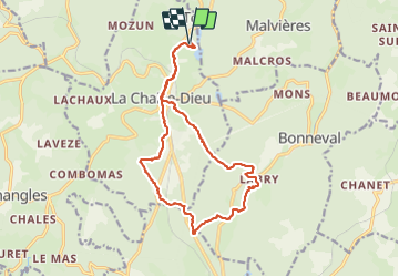
Trail Walking of 17.8 km to be discovered at Auvergne-Rhône-Alpes, Haute-Loire, La Chaise-Dieu. This trail is proposed by Gegetop.
Description
Un joli tour dans le secteur boisé au sud de la Chaise Dieu 😇
Photos


Positioning
Country:
France
Region :
Auvergne-Rhône-Alpes
Department/Province :
Haute-Loire
Municipality :
La Chaise-Dieu
Location:
Unknown
Start:(Dec)
Start:(UTM)
555193 ; 5020212 (31T) N.
Comments